Opinions please - Navionics or Lake master for my Helix?
I've got NOAA charts, know how to use GPS, but looking at what's posted on here and the software websites, there's more on the bottom (topographically) than meets the eye - what have you guys got? And was it/is it worth it?
Or should I be happy with what I have and buy beer with the $200?
Software - Which One?
-
ChessieMan
- Posts: 263
- Joined: Sat Dec 13, 2014 10:48 am
- Species: trout/salmon
-
fishingmachine

- Posts: 860
- Joined: Tue Aug 30, 2011 2:48 pm
- Species: salmon,Lake trout
- Location: Rutland
Re: Software - Which One?
NAVIONICS sonar charts
-
Reelax

- Site Admin
- Posts: 6200
- Joined: Sun Aug 28, 2011 7:27 pm
- Species: Salmon, steelhead, brown trout
- Location: Fletcher, Vt
Re: Software - Which One?
Navionics and you'll never go wrong...
-
ChessieMan
- Posts: 263
- Joined: Sat Dec 13, 2014 10:48 am
- Species: trout/salmon
Re: Software - Which One?
Thanks for the input.
I was leaning toward Navionics, but after researching the issue farther, I found there was a question of compatibility, so I've ended up with Lake Master. I'll let you know how it works out.
I was leaning toward Navionics, but after researching the issue farther, I found there was a question of compatibility, so I've ended up with Lake Master. I'll let you know how it works out.
-
Wallyandre (Andre)

- Posts: 1761
- Joined: Sun Aug 28, 2011 1:34 pm
- Species: salmon, SM, walleyes
- Location: Montreal, QC & Port Kent NY
- Contact:
Re: Software - Which One?
There is absolutly no problem with the HB product and Navionics; it's fully compatible
-
fishingmachine
- Posts: 860
- Joined: Tue Aug 30, 2011 2:48 pm
- Species: salmon,Lake trout
- Location: Rutland
Re: Software - Which One?
If you compares the two side by side you woudn't even think of getting the Lake Master
Re: Software - Which One?
The lakemaster charts are nicer than navionics, but only where they have high-definition mapping. Lakemaster does NOT have high-def mapping on Champlain, which renders the maps all but useless for anything other than seeing general areas of generic depths--you lose the resolution needed to find smaller drop-offs, use it for navigation, etc. Navionics is your only choice that I know of (not familiar with options for Garmin, etc).
-
Wallyandre (Andre)
- Posts: 1761
- Joined: Sun Aug 28, 2011 1:34 pm
- Species: salmon, SM, walleyes
- Location: Montreal, QC & Port Kent NY
- Contact:
Re: Software - Which One?
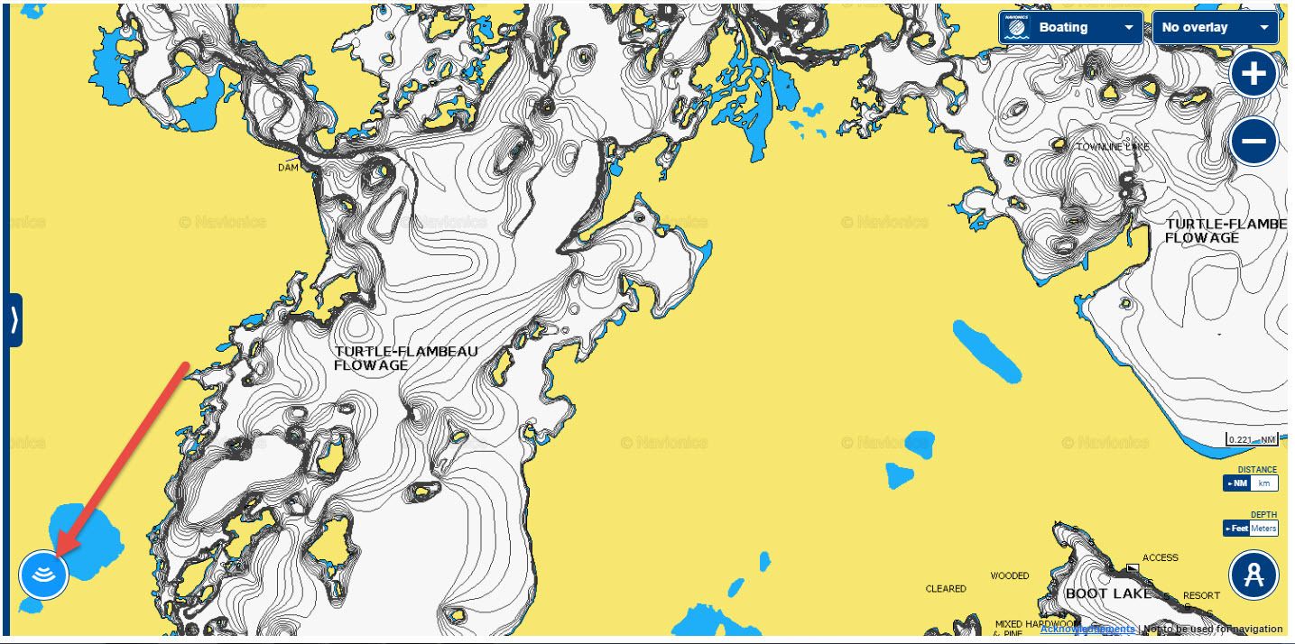
You get SonarChart with Navionics (1ft contour)
What unit are you running?
If you want to see what you going to buy just take a look on the webapp, click on the blue icon on the bottom left once is blue and you are getting the SonarChart
http://webapp.navionics.com/?lang=en#@6 ... itGjej%60M
There is nothing close to Navionics for Lake Champlain and most of the lakes.
-
fishingmachine
- Posts: 860
- Joined: Tue Aug 30, 2011 2:48 pm
- Species: salmon,Lake trout
- Location: Rutland
Re: Software - Which One?
Andre,on my smartphone(android) sonar charts show contours on Lake Bomoseen in Vt. But they don't show Bomoseen sonarcharts on the webb page,how come? and If I want to upgrade my navionics chip to sonarcharts will I get Lake Bomoseen SONARCHARTS on it? Thanks FISHINGMACHINE, I have a Lowrance HDS5-MWallyandre (Andre) wrote:You get SonarChart with Navionics (1ft contour)
What unit are you running?
If you want to see what you going to buy just take a look on the webapp, click on the blue icon on the bottom left once is blue and you are getting the SonarChart
http://webapp.navionics.com/?lang=en#@6 ... itGjej%60M
There is nothing close to Navionics for Lake Champlain and most of the lakes.
-
Wallyandre (Andre)
- Posts: 1761
- Joined: Sun Aug 28, 2011 1:34 pm
- Species: salmon, SM, walleyes
- Location: Montreal, QC & Port Kent NY
- Contact:
Re: Software - Which One?
It shows SonarChart on the webapp also but you need to zoom in until the blue button is dark blue then you click on the button and you get sonarchart
If you buy a Update card you will be able to download the region you want with all the new additions including sonarchart. You can keep you're older card or sell it mentionning to the buyer that he won't be able to use it as an update.
If you buy a Update card you will be able to download the region you want with all the new additions including sonarchart. You can keep you're older card or sell it mentionning to the buyer that he won't be able to use it as an update.
-
fishingmachine
- Posts: 860
- Joined: Tue Aug 30, 2011 2:48 pm
- Species: salmon,Lake trout
- Location: Rutland
Re: Software - Which One?
And BINGO!! there it is! thanks Andre! how dumb do I feel,lolWallyandre (Andre) wrote:It shows SonarChart on the webapp also but you need to zoom in until the blue button is dark blue then you click on the button and you get sonarchart
If you buy a Update card you will be able to download the region you want with all the new additions including sonarchart. You can keep you're older card or sell it mentionning to the buyer that he won't be able to use it as an update.
-
Wallyandre (Andre)
- Posts: 1761
- Joined: Sun Aug 28, 2011 1:34 pm
- Species: salmon, SM, walleyes
- Location: Montreal, QC & Port Kent NY
- Contact:
Re: Software - Which One?
Not that you're dumb, it's not very clear for somebody that look at it once occasionaly!
Re: Software - Which One?
Andre, could you comment on the raw data that is used to arrive at the 1' contours in the Navionics sonarcharts for Champlain? I have been lead to believe that the maps are based on existing nautical charts or low-definition survey and that the 1' contours are not actually measured to that accuracy, they are simply a computer algorithm that interpolates a 1' contour between the existing 5' (or whatever) contour lines. I have several Navionics chips, both premium and platinum, and I can say with certainty that in Champlain there are plenty of places where the 1' contour lines do not reflect smaller-scale bottom contours (i.e. the 1' contour lines show a gradual slope where in reality there is a flat with an abrupt 3 or 4-foot drop in the middle), so this explanation makes sense to me, but in other bodies of water I'm not sure. My chips still work pretty well, but because of this I am a bit skeptical that the 1' contours are actually any improvement for Champlain. I'd love to hear your insight in this, as it sounds like you are involved with Navionics somehow.
Even if true, the lake master maps in HD are great but the Lakemaster maps for Champlain are ridiculously bad--I would not consider them even marginally acceptable as they currently exist.
Even if true, the lake master maps in HD are great but the Lakemaster maps for Champlain are ridiculously bad--I would not consider them even marginally acceptable as they currently exist.
-
Wallyandre (Andre)
- Posts: 1761
- Joined: Sun Aug 28, 2011 1:34 pm
- Species: salmon, SM, walleyes
- Location: Montreal, QC & Port Kent NY
- Contact:
Re: Software - Which One?
In some lakes like Champlain Navionics got some datas from other sources and that is why they can provide such a detail map of lake Champlain. As for the 1ft vs let's say 3ft without actually doing a physical survey, yes it happpt it seems that the algorithm works pretty well because I fish many differents bodies of water and they are 95% accurate. As for this year I use a Lowrance Touch Gen3 with the wifi; evreytime that I start my sonar-gps I connect my unit to my old IPhone with the Navionics Boating App and I just fish without bothering that until the end of the day; what that does? I improve the map so the next time I fish that lake the contours are going to be better & better. If an another guy do the same it's going to be even better and faster. This is the result when you work in community. To add on Navionics for Lake Champlain I can't find any place where the map is wrong and I fish many part of the lake but I also "log" everytime I fish.
Last July I went fishing walleye on a remote lake accessible by floatplane only so no map. The name of the lake is Lake Hebert
This what is available for everybody now:

Last July I went fishing walleye on a remote lake accessible by floatplane only so no map. The name of the lake is Lake Hebert
This what is available for everybody now: